Tag Archives: Colorado

Getting around Denver, Colorado

Denver16thStreetMallAre you planning a trip to Denver? I’m going to a conference here in the city later this month. For folks not familiar with how to get around this area, here are some tips.

  • You don’t hail cabs in Denver. You call them and wait for them to come to you. The hotel may have a taxis at the stand – or not. Uber and Lyft are very popular here. You can also use a car sharing service such as ZipCar.

    Bike Rental


  • Denver was also one of the first cities to have bikes to rent – B cycle . You can rent a bike for $9 for 24 hours at any B Cycle station – but you must have a credit card. These stations are all over the city – you can rent at one and return at another.
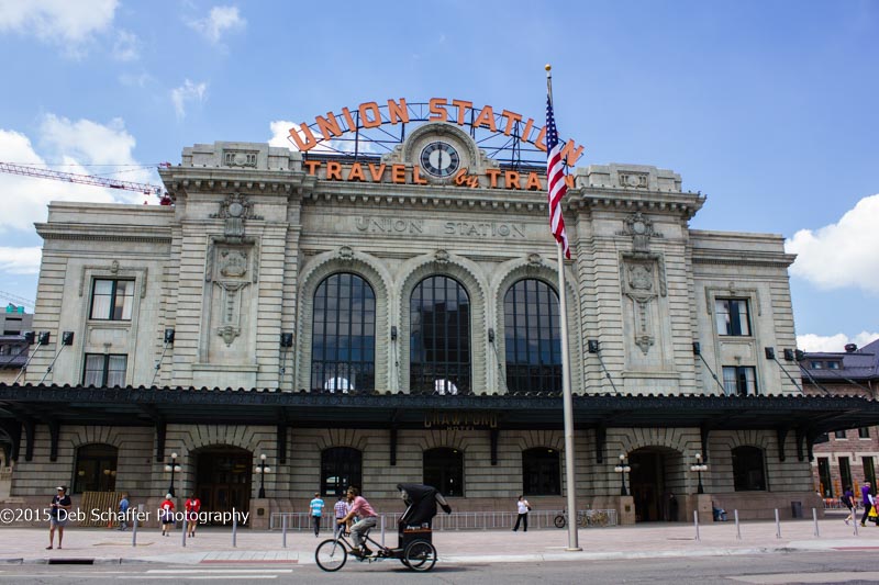
  • In downtown, use the 16th Street Mall Shuttle to get around. It’s free and goes from 16th and Broadway all the way to the Union Station Transit Center. There’s also the light rail and traditional buses. During the week, there are plenty of trains and buses. However, on the weekends, there are often fewer buses and so time between buses is much longer. Light rail is the same, fewer trains on the weekends.

    Light Rail


  • At this time, light rail does not go to the airport. You can get around downtown, and get to some outlying areas, like the Federal Center. Light Rail is mostly used by locals to get to and from downtown for work and special events. In 2016, there will be light rail from the airport. We’re all looking forward to it! Check out RTD for routes and costs.
Denver, Colorado
Union Station, Denver, Colorado
  • Pedi-cabs are also available downtown. You can flag these down on the street and talk to each operator about the cost. These are particularly nice in the evening on the way to or from a nice dinner and show.

    Parking


  • Due to the a building boom here, many parking lots and garages have been replaced by new hotels and office buildings, so parking can be scarce during the week, not to mention expensive. Check out the Park Smart Denver lots first for the best rates. There are also garages and lots just outside the main downtown that can be much cheaper if you’re willing to walk a few blocks either to your destination or to the 16th Street Mall Shuttle.
  • Most of the garages and lots take credit and debit cards. You might check at the outlying lots just to make sure.
  • And finally, parking meters. These are all over the downtown area. They take credit and debit cards as well as Smart Cards (visitors probably don’t have these) and change. Each meter has different costs and time limits so you must read the meter! You don’t want your souvenir from Denver to be a parking ticket.

Do you like this article? Subscribe and receive notice when new material is published. Follow us on Twitter – @debtalkstravel.

Rifle, Colorado: A classic Colorado getaway that’s easy on the budget

Rifle Falls State Park

Emerging from Glenwood Canyon, driving through yet another CDOT construction project we motored past the Hot Springs pool and kept going. I could almost smell the chlorine and sunscreen from the shiny bodies I saw through the fence as we passed by. This time our destination was not Glenwood Springs, but its closest neighbor, Rifle.

Glenwood Springs neighbor

Rifle, Colorado is about 30 miles west of Glenwood Springs along I-70. That puts it about 5 hours’ drive west of Denver. Earlier in the week, we had contemplated visiting Glenwood again, but lack of reasonable hotel rates for the summer weekend led us a bit further away. We decided it was time to visit Rifle – normally just a rest stop along I-70 for these weary travelers.

When one thinks of Rifle, Colorado what comes to mind are shoot’em up old westerns with slightly grubby cowboys snapping matches to flame for hand-rolled cigarettes, lots of cows, and bars serving whiskey. Downtown Rifle is actually quite updated, with a few relics of its old West past. However, as a nod to its name, visit the Shooter’s Grill on East 3rd Street. The wait staff carry weapons along with your burger and fries.


A local hangout


Our very nice room in Rifle was under $100 per night, including a delicious breakfast. Lucky for us, our hotel was right across the street from the Sonic, where everyone was hanging out in the early evening when we arrived. A little ice cream really helps to top off a long drive in the mountains. The next day we would play the Rifle Creek Golf Course for a very reasonable rate. We were intrigued.

Rifle Creek Golf Course

Rifle Creek Golf Course
Rifle Creek Golf Course Hole #2

RifleCreek (1 of 1)-2

Rifle Creek Golf Course

We showed up the next morning, ready to hit the links. The staff at the Pro Shop were very nice, and since we’d paid earlier through GolfNow at about a 40% discount, we were ready to go. The greens fees here are very reasonable, even if you don’t get a discount at $33 for 18 holes during the week. It was a Thursday morning, and we were playing mid-morning as a twosome.

This is a great course to play, even for a high-handicapper. It’s got some beautiful views, particularly from the back 9. The course really fits well into natural landscape of the Hogback Range. We had a blast, and decided that we wanted to come back and play again.

Rifle Falls State Park

Rifle Falls
Rifle Falls

Golf isn’t the only activity we found around Rifle. Rifle Falls State Park is a well-known in the area, and everyone we met asked if we’d been there. The park is easy to find, and visiting Rifle Falls is an easy walk. Visitors can explore the caves beneath the Falls if you like dark and spooky places, complete with bats. Folks can also walk up to the top of the Falls and look out over the park, with the roar of the water in their ears. The campground seemed very full the weekend we were there, so you might need to make reservations if you want to stay.

Rifle Gap State Park

We took a drive to Rifle Gap State Park, not far from Rifle Falls. This beautiful reservoir was being enjoyed by water-skiers, visitors on jet skis, fishermen, and boats just puttering lazily around the reservoir. There was plenty of room for everyone and for a Friday, didn’t look that busy.  There’s a campground not far from the beach that didn’t look too full on this Friday afternoon. But again, I’d check and make reservations if you want to stay the weekend.

Rifle Gap State Park

The Rifle Arch

Before we set off back to Denver, we scouted out the Rifle Arch trail. This hike starts out pretty tame, and quickly advances into a steep climb. Once you get to the top, it levels out again. You can see the Arch from the trail early on, the trail ending just below the Arch. You can hike through the boulder field to get up to the Arch if you have the energy. As you hike, be sure to take in the views of the Grand Mesa and the Hogback Range.

The Rifle Arch
The Rifle Arch

The hike took us about 2 hours round trip. Take water and snacks and decent hiking footwear. There are no amenities along this trail and some steep inclines. We did see families with small children hiking the trail though I’m not sure I’d bring children under the age of eight on this hike.

Find the trail by driving north on Highway 13 out of Rifle. The trailhead is on the east side of the road several miles outside of town. For more information on hiking in the Rifle area, including the Grand Mesa and the White River National Forest, visit the Rifle Information Center, 200 Lions Park Circle, Rifle, Colorado.


A surprising number of activities


Rifle really surprised us. We have traveled through and past Rifle over the past twenty years, often stopping at the rest stop but never venturing further. For those folks that prefer fewer crowds and less chlorine, plan to spend some time discovering this old West town and the surrounding area. I’m sure you’ll be surprised at the number of activities you can find to keep the family busy as well.

Like to learn about Colorado and other fun destinations? Subscribe to our blog and get all the latest updates first.

Castlewood Canyon: Discover Cherry Creek

Pikes Peak
Pikes Peak

The late afternoon is warm, with the requisite clouds over Pikes Peak providing that late day storm to the top of the mountain. The pine scent is heavy – it seems much richer than any fragrance you can buy. The hummingbirds are providing their buzz, sounding like a slightly off-key piper making a weak attempt at musical scales. The path to the overlook is busy, but not with people.

Castlewood Canyon State Park is a small slice of wilderness an easy drive from the big city.  It’s just a bit over an hour’s drive south of Denver, Time stops here for the deer, fox, coyote, birds and other creatures that can handle close proximity to people. It’s a popular location for day hikers, cyclists, and rock climbers as well as families enjoying picnics overlooking the creek.

Resident of the Canyon

This State Park was born of disaster. In 1890, the Castlewood Canyon Dam was completed by the Denver Water Storage Company, holding back Cherry Creek. The dam leaked from the day it opened.

Once the dam was in place, homesteaders started populating the area. In 1901, the Lucas family’s application for land was approved. The family lived in an area inside what is now the park for many years. Visitors to the park can visit the original homestead and see the walls of the house near the West entry to the park.

Homestead in Castlewood Canyon

In 1933, during a heavy rain the dam gave way. A wall of water 15 feet high flowed down through the Canyon and towards the town of Denver. Luckily, the dam operator made it the 12 miles to reach the nearest phone operator, who could then warn the residents downstream. The wall of water pushed into Denver down Cherry Creek, flooding streets, demolishing bridges and  causing havoc in the city.  It took months to dig out from the mud and debris, and begin repairs to roads and bridges.

The ruins of the dam.

The dam was never replaced. Visitors to the park today can see the remnants of the structure in the center of the park. The Creek Bottom hiking trail along Cherry Creek is where visitors can retrace the path of the flood and sit on the rocks near the waterfall. For those not so ambitious, there is a road that goes through the park, passing the top of the dam. There is a parking area for access to the Westside Trail area, picnic area and restrooms.

Castlewood Canyon State Park

The main entrance to the park is on the East side, off Highway 83. Day passes are $7. Holders of a State of Colorado parks pass get in free. The Visitor’s Center provides an overview of the area and a short video that describes the history of the area. The rangers are very knowledgeable about the park, and can point you to the latest birding spots or trails to suit your abilities.

The Canyon Overlook trail is one of the most popular. It’s a short easy hike that ends in a gazebo and overlook. The layers of rock across the canyon are home to birds and small animals. At the bottom of the Canyon, you may see hikers following the creek around to the remains of the dam. The hummingbirds provide the background soundtrack, along with the raptors that nest in the park.

The Overlook
The Overlook

There is no overnight camping in the park, and rock climbing is reserved for a few areas in the park. The rangers can point you to the climb sites. For great views of Pikes Peak, follow Castlewood Canyon road out of the park. Dogs are welcome in the park, as long as they are kept on six-foot leashes and keep to the established trails.

The falls at Castlewood Canyon

The East Canyon Preservation area welcomes hikers on the established trails, but no dogs or other pets are allowed. This area is fragile.

For more information on Castlewood Canyon State Park, visit State of Colorado. For more information on the history of the dam, visit CherryCreekBasin.org for personal accounts of the night the dam failed.


Roadtrip to Los Angeles

Utah mountains
Utah mountains
Utah vista
Utah vista

Packing the car to the roof, stashing the pretzels and the water, and putting the maps on the floor, my son and I were ready for a road trip to the Los Angeles area.

M was moving to Glendale, California. He had rented an apartment with a friend and didn’t yet have a job. He had been working for about a year, saving his money and spending mine. Finally it was time for the big move. We were driving from our home near Denver to California via I-70 and I-15.

We left early on a Wednesday, only getting stuck once in rush hour traffic. Our trip over the Continental Divide was uneventful – though we did see the half-pipe and cross-country ski course at Vail from the highway. I can’t imagine snowboarding on that crazy thing!

After lunch in Grand Junction, we headed out across Utah. As we headed south past the National Parks, it started getting warmer and the snow disappeared. About St. George, M said he was ready to go straight through to Las Vegas to spend the night.

Pulling out the trusty smartphone, I download Hotels.com and started searching for a place to stay the night. This was a Wednesday night which is less pricey than the weekend. Hotels.com doesn’t sponsor this blog, but I got a great deal on a nice hotel on Flamingo Road. We ended up paying 29.00 for the two of us to stay at the Tuscan Suites, just down the road from the Westin. The room was large and lovely. Thanks Hotels.com!

The beach at Santa Monica
The beach at Santa Monica.

The next day, we headed into the north Los Angeles area. Our four hour drive took us through the desert, past the San Bernadino Mountains and into the Hollywood Hills. Compared to Colorado, this place was green and shiny!
We found the apartment, and with the roomate’s help, moved him in. The attraction of Southern California over the Front Range of Colorado is evident in the beautiful and warm sunny days.  We did hit some of the tourist sites before I had to fly home and return to work – the Warner’s Studio Tour and the Santa Monica Pier. What a great feeling to walk on the beach in January.

On the
On the “Friends” sofa at the Warner Brothers Studio

Since he didn’t have any furniture, I rented with AirBnB – Mama don’t sleep on the floor any more. My host was very gracious and we had a great time during the few minutes we had in the mornings and in the evenings. Thanks to AirBnB and Grace for a comfortable stay.

Now that I’m back home and cleaning out the room he left behind, I’m hoping to get back to a regular blogging schedule. Stay tuned for more tips on how to plan your vacations!

Denver, Colorado and the new Union Station

On Saturday my husband, a friend, and I went downtown on the light rail to see the new Union Station makeover. It was a nice Saturday afternoon, and we headed downtown to be among the first to see the new hotel built at Union Station.

Union Station Denver
The outside of Union Station in Denver, CO
UnionS tation Inside
The interior of Union Station in Denver Colorado

Union Station in downtown Denver has been a hub of Amtrak activity for about 100 years. The California Zephyr pulls out at about 7 a.m. most days, headed West to San Francisco. If you’re headed to Chicago, the train leaves around 7 p.m., headed East. This building used to be in the worst part of town and had become neglected and avoided.

In the past few years, developers have been working  redevelop the property around the train station and create a consolidated transportation hub. They have succeeded admirably.

The refurbished train station has a Victorian charm with a current twist. The the chandeliers invoke an old-world elegance, while the new vendors work in updated spaces. This building is now a centerpiece of lower downtown, a finishing touch to the years of work rebuilding and re-imagining the City of Denver.

The Oxford Hotel
The Oxford Hotel

Within a few blocks of the train station is Coors Field, the home of the Colorado Rockies. Down the block from the front door of Union Station is the Oxford Hotel, one of the premier boutique hotels in Denver. Great restaurants and bars are also nearby, particularly if beer is your beverage of choice. Denver is home to many great breweries and we stopped at one of the most popular, the Rock Bottom Brewery on the 16th Street Mall. With a bit of the brew and some nachos consumed, we were refreshed enough to ride the mall shuttle to Union Station and head for home.

The official grand opening of the new building, including the transportation center, will be at the end of July 2014. We can’t wait to go back and join the party!

Palm Springs, California roadtrip

Palm Springs sign
Palm Springs sign

Earlier this month, my husband and I jumped in the car and hit the road for Palm Springs. From Denver, the drive is about 15 hours straight through. We had decided we wanted to do a getaway, and after adding up the numbers to fly and rent a car in Palm Springs, California, we decided to drive. Our intent was to find some warm weather, and get in a few rounds of golf.

It was a blast. We spent the first night at our friends in Prescott, Arizona. From there we headed out to the Coachella Valley and the Southern California desert. We learned a few things along the way.

Arizona has some beautiful landscapes. We cut across southwestern Arizona on our way from Prescott to I-10. There were some pretty desolate areas we passed through on our way.

Coming into the Coachella Valley is a beautiful drive. Quite frankly, I-10 through the desert is not all that interesting. But once over the ridge on the way into the valley, the views are spectacular. I wish there had been somewhere safe to stop the car and take a few photos!

Palm Springs seems to have a golf course on every corner. It seemed like quite a dichotomy that this city in the desert had all these green golf courses. I’m sure that’s a discussion the residents are having as we speak.

The Tahquitz Golf Course - Legend Course. Hole 4
The Tahquitz Golf Course – Legend Course. Hole 4

The Palm Springs Follies, an institution in town, is closing this year for good. This show has been going on for 25 years. The performers are all over the age of 55 and do a great show. The Master of Ceremonies, who always manages the show, was happy that the shows were sold out through the end of the run but he wondered where everyone was the past few years!

The drive through Utah on I-15 and on to I-70 is still stunning. This drive passes two national parks, Capital Reef and Canyonlands, as well as the Grand Staircase-Escalante National Monument and the Dixie, Fishlake, and Manti-LaSalle National Forests. You’ve got to stay alert as you drive through the passes. Luckily, there are plenty of overlooks to rest and enjoy the views. If you haven’t made this drive, put it on your list.

I’ll be posting additional posts on this trip over the next few weeks, but these are my first impressions.

Roadrunner at the Living Desert Zoo

Glenwood Springs on a budget

Mount Sopris
Mount Sopris

Following the Colorado River as if flows into Glenwood Canyon, the terrain abruptly shifts from green valleys and rolling hills to severe rock walls with the thundering river below. Rafters and kayakers bob in the water, steering their craft through the boulders and white water. This is the last section of the highway before entering Glenwood Springs, Colorado.

Glenwood Springs is a great getaway from the Denver area. There are plenty of low cost and no cost activities to experience in and around the town. Take the family and try some of these.

Hiking. There are many miles of hiking trails in the Roaring Fork Valley. From the paths along the river to those up Storm King Mountain, there are trails for every level of adventurer. For those who like to climb mountains, the 12.6 mile round-trip track to the top of Mt. Sopris is not a technical climb, though it is for the advanced hiker and can be done in a day. The 4-mile round-trip hike up Storm King Mountain ends at a memorial to the firefighters who died in 1994 fighting a wildfire.

Hiking trail
Hiking trail

Biking trails. Biking is a great family activity and there are trails for every skill level. For the hardcore mountain biker, there are steep, technical trails on Red Mountain. For a bit tamer ride, the Glenwood Canyon track follows the river and has stops at the rest areas along the highway including Bair Ranch, Hanging Lake, No Name, and Grizzly Creek. The Rio Grande trail connects Glenwood Springs and Aspen and follows the old railway between the two towns. For those who prefer a downhill ride, catch the RFTA Bike Express for a ride into Aspen. Then unload the bikes and ride the mostly downhill 44 miles back into Glenwood Springs. The Bike Express runs on weekend mornings from May to early September. For more visitor information about the bike trails around Glenwood Springs, check out Visitglenwood.com.

Rafting down the Colorado River

Tubing and rafting on the Colorado and Roaring Fork Rivers.  Tubing on the Roaring Fork and Colorado Rivers is a whitewater lovers dream. Put in your craft at Two Rivers Park and float down the river in the slow current. For kayakers, the town has one of the few locally supported whitewater parks. Rent tubes in town for about $16 each, bring your own boat, or take a professionally guided rafting trip with one of the many tour providers.

Fishing. For those who like to cast lines, Glenwood Springs is a great choice. With both the Colorado and Roaring Fork Rivers home to many different varieties of trout, it’s never a bad day to go fly fishing. The river is accessible, with many different locations where it’s possible to park and walk down to the water for wading and shore fishing. There are many different streams that feed the major rivers in the valley, including No Name Creek accessible from the exit about 1.5 miles east of Glenwood Springs. If brook trout are your quarry, try Grizzly Creek. This is also an exit off I-70 east of town. Visitors can park in the main lot and hike back to find your spot. If you prefer company, there are guides and outfitters available to rent equipment and find an out-of-the-way fishing hole.

With the rivers spilling out the canyon and the sun shining, Glenwood Springs enough activities to keep an entire family busy without breaking the bank.

Like this article? Subscribe to receive an email when new material is posted.

The rainbow rocks of eastern Colorado

Pain Mines Park, El Paso County, ColoradoAn easy day hike on the eastern plains

The sun shines in Colorado almost every day, and this was no exception. The morning was clear, and watching the antelope sway across the prairie and the horseback rider move cleanly up the ridge in the distance was worth the hour in the car. I was headed to Calhan, Colorado and the PaintedMinesInterpretivePark in El PasoCounty, about an hour east of Colorado Springs and about two hours south of Denver.

Rolling into the parking lot first thing in the morning, the view included the gently sloping hills and prairie in the distance. Grabbing my hat and camera, I headed down the easy trail toward the hills. The grade started to increase as I passed a family with a small child who was chasing butterflies and watching birds. Although the bench at the top of the hill looked inviting, I kept going and around the corner and the formations came into sight. It was amazing to see the white, red, and orange badlands appear suddenly from the prairie.

Overlooking the plains.

Winding down the wild-flower rimmed trail, the hoodoos and spires were more intimidating as I got closer. As I made my way around the north side of the area, the trail headed up again to an overlook. In one direction, the vast prairie laid out with trails. In the other direction, the stark white formations looking like frozen, rocky, milk. The pale rocky falls fronted the colorful rock layers in the rest of the park. I made my way to the rainbows in the rock.

The clay and sandstone formations are gently formed by wind, rain and blowing sand. The gullies and caves that are carved out of the rock form an intricate maze of color and shadow. This red clay found in these formations was mined to create pots and used as ceremonial body paint by the Indians. This was also a hunting ground for the first inhabitants because of the abundance of deer and bison in the area. In the early 1880’s the first settlers homesteaded the area.

Wildflowers along the pathThere are about four miles of trails in these 750 acres. Around the formations, the trails are actually dry stream beds. In this area, the weather can change quickly and flash floods create the trails as the water runs off. The wildflowers are blooming wherever they can get a foothold and the paths are lovely. A frequent visitor to the park mentioned that often artists set up easels in the morning to paint the beautiful landscape.

The particulars: The Park is open from dawn to dusk 365 days per year and is free to the public. The hiking is considered easy here, though be aware that there are some steep inclines. The services include a few picnic table, a few benches along the trails and a toilet near the main parking lot. This park is not designed for wheelchairs. There are two additional overlooks to the park with short trails to small picnic areas that seem more accessible.

There is no overnight camping allowed in the park. This is a great park for kids, though climbing or disturbing the formations is illegal. Visitors should bring their own water and be aware that it can be quite hot on a summer afternoon and there is very little shade.

To get to the park, take I-25 to Highway 24. Go east on Highway 24 to Calhan. Once in Calhan, go south on Yoder Toad/Calhan Highway, then turn east on Paint Mine Road and follow the signs. For more information, visit the El Paso County website.

Deb Schaffer is a local Denver travel writer and golf enthusiast. Check out her articles about Denver travel deals on Examiner.com and golf course reviews at BoomerGolfBliss.com.